Welcome

Welcome to the Balsam Blog, home in the internet world of the Falkland Islands Protected Areas Project.

I'll be using this blog to let people know what I've been up to and to share bits of useful information I pick up along the way. My project is subtitled 'Co-operative management of biological diversity', so that means you. The project will need your knowledge, concerns and hopes for the future to drive it along, so do contribute.

Thursday, 6 December 2012

Invasive plants; What is your vision for the future?

I was in town last week to help facilitate a workshop for Richard Lewis to help him develop an Invasive Plants Strategy for the Falklands. It was really well attended, with about 25 people from government departments, conservation organisations and the wider community, who took part in a range of activities to generate ideas and establish priorities for tackling invasive plants in the Falklands.
In one activity early on in the day, groups worked together on a picture very kindly provided by Ben (did I tell you my husband is an artist and designer?). They had two copies and had to annotate and draw on them to show two visions of the future; one was to be a positive vision of how we think the islands might look if we develop and implement a suitable strategy, and the other was a vision of how the islands might end up if we don't.
The apocalyptic 'bad' versions were useful (and entertaining), but I was most interested in the 'good' visions. Some interesting ideas emerged; one was that we can't hope to eliminate all invasive plants, but need to concentrate on identifying and tackling the really bad ones. Everyone was in agreement that even more important than this will be education and information, and good biosecurity to stop things getting in in the first place.
I was most struck by Jim McAdam's vision of the future (many of you will know Jim from his 40 years of work with agriculture in the Islands). He spoke about the need for the Camp to be settled, lived in, and managed for people, agriculture and nature.  We can't turn the clock back to a time when people weren't here, and we don't want to; in that case we need a flourishing Camp community to look after the countryside, and part of that will involve tackling  invasive plants.
Stinging nettles on Middle Island
I'd like to thank everyone who came for taking part in all the activities so enthusiastically. I'd also like to thank Richard for inviting me to facilitate, and my co-facilitator Brian who kept us to time, among other sterling contributions.

Wednesday, 14 November 2012

So what does 'GIS' actually mean for us?

You are not alone in asking that question! When I trained in Geography 20 years ago, it was the new thing. I then put it to one side and hardly thought about it, until now.......

GIS stands for Geographical Information System.
It's a way of storing, organising and presenting information, and combines mapping, databases and statistics.
You probably have some experience of this already, if you have ever used satnav, or GoogleEarth, or a handheld GPS, or if you've tried to get rid of that irritating map on facebook.

 Basically, you start with a base map. This is usually a really good satellite image. The newer satellite images can have a pixel size of 0.5m x0.5m!
You load this into your computer program, and then you can start adding more data, a 'layer' at a time.
So for example, if I went to Hawks Nest Pond today (what a great idea), I could take my GPS and walk the boundary of the new reserve. I could then save this data in the program and produce a new map. This would be a really small data set! If you counted all the albatross in the islands, or entered all the climate data for the last 50 years, you would be using much bigger data sets.

Once you have some data and some base images, you can start to ask your GIS to do all kinds of amazing things.


If I had the digital version of the geological map, and my Hawks Nest Pond boundary, I could find out what kind of rocks and soils were there. If I had done the right work on the plant records for the islands, I could predict what kinds of plants would be most likely to grow there; by combining the data set for 'places where we have found silvery buttercups' with the geological map, we could start to make predictions about other places where they might be found growing.
GIS also allows us to map and interpret changes over time. This is likely to be particularly useful if we really are experiencing a changing climate. We can look at all kinds of relationships between rainfall, changing vegetation cover and land use, to help landowners and managers to make decisions about how to get the best from their land in the long term.


Why now?

GIS has clear benefits for conservation planning; if you have data about the important species and habitats you want to conserve, and other data about the land available for conservation, either because it's already a nature reserve, or because it's publicly owned, or because its owners already manage it for conservation, then you can start to assess how you are doing and what you need to do next. There are various tools around to help with this. One is a computer program called MARXAN; you put all that data into it, and it tells you where you should be focussing your efforts.
One of the objectives of the Protected Areas Project is to have a good look at MARXAN to see if it would work for us. Over the next few weeks I'll be putting out some feelers to try to find out what data is available to use for this- this kind of thing is only as useful as the data you put into it. Unfortunately, there are a few stumbling blocks right at the start:
  • satellite imagery; you know how I said at the start that you need a high resolution satellite image.....well, we don't have any. They are expensive. Who will pay?
  • data; masses of high quality data has been collected over the years but it is all in different places. I haven't tried too hard to look for it yet, so wish me luck with that!
  • a base map; there seems to be a digital map produced by the military, but we don't seem to be able to use it. Otherwise we are reduced to a scanned version of the 1963 OS map. Or GoogleEarth; have a look at the image for Sea Lion Island for a demonstration of the limitations of this!
We are not downcast by this; the South Atlantic Environmental Research Institute has this right at the top of its agenda; an island wide GIS is what we need, and this time around, we might actually be going to get it. It opens up a whole new can of worms, to do with data and copyright issues, and whether we all give up our data to allow other people to use it.

(The images are from a presentation given by Justin Moat, head of GIS at Kew. I wish I could explain it as well as he did.)

Tuesday, 6 November 2012

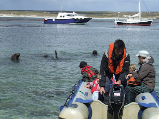
Extreme photoshoot


A behind -the- scenes look at Barnaby's latest photoshoot. He wanted everyone to know what he goes through in pursuit of excellence. Note the safety measures- we are following health and safety regulations even on Sea Lion Island.

Wednesday, 24 October 2012

It's finished!


This is the last time I will talk about interpretation for a while, but I wanted to share the finished article.
The criteria for this leaflet were quite narrow:
  • it had to be small enough to fit into a child's pocket
  • it had to be sturdy enough not to blow away or crease up too badly
  • the text had to be readable by someone who's only 6
  • it didn't need to teach anything new; the children should already know about the animals and plants, and will have learnt about biosecurity and the countryside code. 
  • it had to give them something to do if teachers and helpers found their attention flagging
The trip to the island will take place in a couple of weeks time. I'll be looking forward to hearing how it went.

Monday, 22 October 2012

Less is more

 I have been doing a final piece of interpretation for the school kids to use on their trip to Kidney Island this year. The Barnaby Bear books and activities are intended for use in the classroom. However, on last year's trip, fab though it was, we all felt that there were moments when the children needed a bit more direction. I'm not a fan of unwieldy worksheets on school trips, so I've gone for the very simplest of trails, based on the senses.
The text is not finished yet, but I just wanted to share Ben's illustrations because they are really great. He says he hasn't done anything like this before! I'm keeping the text to a minimum; the children are only 6 or 7 and they don't want to spend their trip reading. It's often tempting to try to cram as much into a leaflet as possible, but it's a mistake. Fewer words, backed up by great illustrations and activities to do can have a much greater impact.
I'm putting together an evaluation sheet for the teachers; if we all like the materials, there will be more for other places, of both the leaflets and the Barnaby Books.
Where do you think we should do next?

Friday, 5 October 2012

More fame for Barnaby Bear!


As a bit of light relief from some of the more heavy duty tasks on my desk, I have been turning the pictures we took of Barnaby Bear on Kidney Island into a story book and accompanying teachers' notes. I am very lucky to have a tame graphic designer living in the same house, who is giving me a very good rate.
 I used to do this sort of thing for a living so it feels reassuringly familiar after exploring some of the wilder reaches of protected areas systems planning. The activities are loosely based on the current Y2  science curriculum, and the text is layered, from about level 2c to about 3a. In non- school -speak, that means it should have something for anyone up the the age of 8 or 9. It should also be suitable for multi- age schools, which are the norm in Camp Education.
The pack is just about ready to see the light of day; it will be printed locally and trialled in support of this year's visit to the island. If we like it, I'll get more copies printed for general use and sale at cost. The rights to Barnaby are owned by the Geographical Association and we are very grateful to them for permission to share Barnaby's travels with a wider audience

Tuesday, 18 September 2012

A new nature reserve for West Falkland

I took a trip along the road today to see how our expert fencers Di and Leon are getting along, as the new fence at Hawk's Nest Pond is getting put up today. As mentioned previously, the pond and its immediate surroundings were gifted to Falklands Conservation in memory of Lyn Blake who farmed the area for many years, and were are very grateful to Tony Blake for his generosity.


 Now that the fence is nearly complete, it feels like a proper reserve and we can
begin to think about how to manage it for conservation and public access. It seems likely that this will fall within my remit; it isn't a legally protected area, but it does give me a further opportunity to test some of the ideas that are emerging out of the Protected Areas Project, and a legal designation may well be applied for in due course. It also provides an opportunity to make conservation activities accessible to the community and help us all to appreciate the potential benefits of protected areas. Small areas such as this can be valuable for many reasons; they provide refuges for vulnerable plants, they protect and improve habitats for birds and invertebrates, and they provide an easily accessible place for a picnic and a bit of bird- spotting.


It's a bit early in the season for spotting many birds, and the club- rush stands look pretty dead, but in a few weeks time the site will be full of life and growth. We all agreed that a reserve opening ceremony with a few celebratory lemonades would be appropriate; I'll keep you posted and issue an invitation soon.

Wednesday, 12 September 2012

What do you love about where you live?

Children's answers in art on display at the Falklands 30 Exhibition


I know this was quite a long time ago now, but I just wanted to share some of the fantastic art that the children produced. Thanks to you all, and to the teachers at the Stanley Infant and Junior School and Camp Education who helped me to put up the display and the artists who gave their time during the theme week back in March.


Tuesday, 11 September 2012

What do people really want to do in the great outdoors?

Well, it depends who they are. I know that sounds obvious but it's something I've been thinking about a lot in recent weeks.
As I said before, there are plans afoot to invite the public into the Patricia Luxton National Nature Reserve (Chartres). To make sure that the biodiversity values of the site are properly looked after, we need to think about who our visitors are likely to be and what they will want to do when they get there.
I started off with a desk exercise that turned into a sad failure; the census wasn't out yet, the ferry company only have the vaguest idea of who uses the boat. Not to worry; this kind of crude numerical data doesn't give us much of a clue about what visitors needs and motivations might be.
So I tried something else. I roped in a tame West Falkland family and did an accompanied visit to the site, observing and recording what they did as self- chosen activities, and asked them what they thought would make a future visit go with a swing. I'm quite interested in this kind of research, especially with children and families; generally they know what they like, and have plenty to say if you know how to listen.

When I got home, I analysed what I'd seen in the light of a book I've been reading about visitors to museums, 'Identity and the Museum Visitor Experience' by John H Falk.

What kind of visitor are you?

An explorer?  You might visit a place out of curiosity. You value learning but you aren't an expert. You don't want your visit to be too structured.
A facilitator? You are interested in the needs of the other people in your group; you might be a parent or grandparent wanting to share a hobby or enthusiasm.
An experience seeker? You like to collect experiences so you can say you've been there and done that. You seek out the famous and iconic.
  A professional or hobbyist? There aren't many of you out there but you are very influential. You probably know what a brittle bladder fern looks like, and you want to find one
A recharger? You are most interested in soaking up the atmosphere of a place. You might take a book, or a picnic, or a yoga mat.

The truth is, most of us can be most of these depending on who we are with and where we are going. We can also change from one to another within the course of a single visit.

The trick is to make sure that you provide something for everyone if you can.

The message I took away from this visit to Chartres is that the site is lacking the famous and iconic, and the professional fern- seekers are only likely rarely to pass by. That means we need to work a bit harder to make sure that people know this special place is there and to help them to enjoy it to the full once they have decided to visit.


Tuesday, 21 August 2012

Protected Areas Designations Workshop

Nick gets creative...No, don't like that.....but how about this?
A couple of weeks ago, there was a workshop in Stanley to discuss options for making our system of Protected Areas more appropriate to our needs.
At the moment, we have National Nature Reserves, the means to create National Parks (although we haven't actually got any yet), and some non- statutory scientific designations such as Important Plant Areas and Important Bird Areas.
The workshop was open to the PA Project Steering Group, some other experts and policy makers that I thought needed to know what was going on, and any landowner who wanted to attend. I was really pleased that quite a few landowners did come as this issue has the potential to affect them most of all, and we need to find solutions that are broadly acceptable to everyone.
The main issues being chewed over were:
  1. Should the current NNR designation be subdivided so that it reflects the different uses and management of protected areas? If so, how?
  2. Is there any way we can provide more protection to the most special places and habitats without necessarily applying a full-on legal designation?
I haven't finished analysing and writing up the results of the discussions yet, but a few patterns have emerged from discussion 2:
  • We were broadly agreeable to producing a map of the best places for wildlife, and protecting them from develoment that might harm them through planning regulations and policy (as long as it doesn't affect traditional small scale activities)
  • We didn't like the idea of any kind of monitoring!
  • We all wanted more support and guidance in how to manage these special places for wildlife
The issue of public access provoked strong feelings both ways. Landowners were generally not in favour of automatic access to these sites for the general public. I don't want to pre-empt my final recommendations, but at the moment I can't see any reason at all to change to the current arrangements for access. All of our discussions pointed to co-operation and agreement as being the way forward, and forcing a change in this area doesn't seem to deliver the best outcomes for wildlife or the community.
I'd like to hear anyone's views on this subject. I don't name individuals in reports, but I do listen and make sure everyone gets a fair hearing.
Paul shows Jan his 'bottom line'

I'd like to thank everyone for giving up their day and working so hard. Special thanks to Nick Rendell for setting the scene, and Jo Tanner for sharing her experiences of Landcare. Also to Helen for doing the washing-up afterwards!.

Thursday, 16 August 2012

I'm back!

Hi everyone,

Sorry I seemed to drop off the face of the earth there for a while. I was away at RBG Kew for a couple of months doing some training, and have been flat out with consultation meetings and other similar activities since then.
I'll try to catch up in the next week or two and let you know what I've been up to.

One thing I'm working on right now is a plan to open up a new nature reserve, Chartres Horse Paddock on West Falkland, owned by Bill Luxton, to sustainable public access. I've been wrestling with management planning, interpretation plans and so on, and a funding application to the Environmental Studies Budget (fingers crossed for that). All quite dry and difficult.
So I was pleased to get some nice mail today; a Trails Toolbox and Happy Families Toolkit that I ordered from Kate Measures. I met Kate at Kew, and I want to give her a plug as she is full of excellent down- to- earth advice and support for anyone wanting to develop interpretation at any kind of visitor attraction. (Alternatively, you can ask her consultancy firm to do it for you!) http://www.katemeasures.co.uk/home


I hope to be able to pick up some tips to help Bill develop something really great at Chartres Horse Paddock . I'll be looking for volunteers to act as guinea pigs later on this season.

Wednesday, 4 April 2012

Have you seen these plants?


I have been having a tidy up of my desk at conservation towers and found some CD copies of Rebecca Upson's guides to identifying these and other special plants of the Falkland Islands. If you would like one, do drop me a line and I'll put one in the post for you.


Monday, 12 March 2012

Public Consultation Workshops

I have been putting together some presentations for the first phase of the wider public consultations on the Protected Areas Strategy. The Project Steering Group has already done some work on the fundamental principles that will guide the strategy; now it's time to ask the wider community what they think.
After several months reading around  the more obscure corners of protected areas theory and research, it's been useful to go back and ask 'What are protected areas for?' and 'Why do we need to think about this now?'. I've gathered what I think are some useful points and I'm looking forward to hearing what friends and neighbours on West Falkland think.
The first two workshops are this Wednesday at Fox Bay, 7pm, Southern Cross Social Club, and Thursday at Hill Cove Club, same time. I hope people will go if they have something to say or want to learn more; the strategy will move on anyway, and this is a good chance for the community to help define what shape it will take.

I'll leave you with this to be going on with. It's not final, but it's not secret either.It will be aired at the meetings, after which a final version will become the first part of the Strategy:


Our principles for building the protected area system
Building on scientific guidelines and national and international commitments, the following principles have been developed for the Falklands through the Falkland Islands Protected Areas Strategy Project.
The highest priority is to develop a comprehensive protected areas system that includes the full range of the Falkland Islands’ plants and animals, landscapes, seascapes and ecosystems for the conservation of biodiversity and for the use and enjoyment of present and future Falkland Islanders.

Conserving natural landscapes, ecosystems and species
The system will include enough areas and sufficiently large areas to allow for ecological viability and the survival of species.
We will give priority to protecting areas that we know contain concentrations of special species and habitats.
The protected areas system will be designed to build in resilience to environmental change.
We will look for opportunities to act to help wildlife at a landscape scale to encourage connections between protected areas. (Not finalised)

Providing social, health, educational and economic benefits to the community
Socio- economic impacts and benefits will be considered. Stakeholders will be fully consulted to ensure that the maximum benefits are realised and negative impacts avoided.
Educational opportunities and health benefits provided by the enjoyment of protected areas will be actively promoted.
Cultural, scenic and heritage values will be considered when choosing areas to protect.

Practicality and urgency of designation and management
The legal and regulatory framework will ensure that any development within protected areas does not conflict with the aims of the designation.
Consistency will be achieved by the application of standard criteria and processes for the creation and management of protected areas.
Availability, practicality and future costs of management will be taken into account in the selection and prioritisation of protected areas.
The level of threat to defined biodiversity areas will be considered in the prioritisation of designation.

Sunday, 11 March 2012

Falklands 30 Theme Week

We had a great week in the Infant and Junior school and Camp Education thinking about what we love about the Falkland Islands. Sixteen Falklands artists and craftspeople gave up their time and shared their enthusiam and expertise to teach the children new techniques and help them to realise their ideas. 
The art that the children produced will be photographed properly and exhibited in the school on June 13th; meanwhile, here are some pictures of some busy hands at work to give you an idea of what we got up to.
I'd like to thank everyone who took part, children, teachers and volunteers. What a great effort by you all.


Monday, 13 February 2012

What do you love about where you live?

As part of the preparations for the commemoration of the 30th Anniversary of the Liberation of the Falkland Islands, the Infant and Junior School and Camp Education will be holding a theme week of linked lessons and activities. The Week begins on 5th March and will focus on both the past and the future, gathering memories and eye- witness accounts of the conflict, looking at how the islands have changed in the last 30 years, and thinking about what we love about our home now.

We camped in the valley - it was a great place to wake up.  It was great here.  It was a bit windy the day before and rainy in the night but in the morning it was calm, it was awesome just like a mirror lake. (Jack Cartwright)
The Protected Areas Strategy Project is helping to sponsor and organise the week, and we plan to involve local artists in workshops to help the children turn their ideas about Falklands landscapes into art using different media. This is an important first step in encouraging children, families and the wider community to think about what they value about our natural heritage.

Some children have already sent some photos; they will be laminated and used as a resource bank for the theme week. We still need more photos, and a few words about them makes them even more special. Email them to me at protectedareas@conservation.org.fk

Friday, 3 February 2012

Barnaby Bear's trip to Kidney Island

Stanley recedes rapidly into the distance. The launch was very fast!

Arriving at the island.

Kidney Island is home to breeding shags and rockhopper penguins.

We saw plenty of Cobb's wrens and tussac birds on our way along the beach.

The sea lions said goodbye.

Barnaby arrived in the islands last week and was able to join the Year 2 children fron the Infant Junior School and Camp Education on their trip to Kidney Island, a small nature reserve not too far from Stanley.
The island is home to an amazing variety and quantity of wildlife, being free from introduced mammals.

I took lots of photos and hope to turn them into a book for children, once the necessary permissions have been sought from the parents.

The trip was funded, as it is each year, by the Falkland Islands Government through the Environmental Studies budget, and we were all very grateful to them, as well as to our helpers and guides Ken Passfield, Sonia Felton and Maggie Battersby, for this amazing opportunity.

Thursday, 12 January 2012

Barnaby Bear Heads South

Barnaby Bear posed for a picture in his birthplace, Apley Woods, before heading south to take up his new position as official Barnaby Bear of the Falkland Islands Protected Areas Strategy. Barnaby has been given permission from the Geographical Association to travel to the protected areas of the Falklands to find out what makes them special and how they are looked after and to feature in books which will help children in school learn all about them.


''I'm not much looking forward to spending the next two weeks inside a mail bag," commented Barnaby, "but I am looking forward to visiting Kidney Island with the Year 2 children of the Infant Junior School when I get to the Falklands. It's a great opportunity for a bear and I feel very lucky."
Barnaby Bear is also hoping to travel to Steeple Jason Island later in the year. He'll let us know how he gets on.

Tuesday, 10 January 2012

Homage to Andy Goldsworthy


This has little to do with Protected Areas, beyond helping children to appreciate their surroundings and respond to them through art. It's mainly just something to do on a beach on a nice day, in this case the Sound at Hill Cove. If you do it with children, you can specify the number of items, the shape the sculpture has to make, whether the items were once alive or never alive (always a hard idea for little children to grasp).....endless possibilities.